
Discover Colombia'sMost Extraordinary Places
From the Caribbean coast to the Amazon jungle, each destination tells a different story of the world's most biodiverse country.
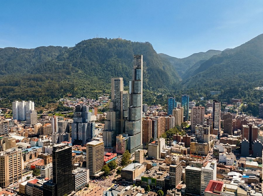
Bogotá
Bogotá is not what most travelers expect. At 2,500 meters above sea level, it runs on cool air, strong coffee, and a creative energy that most people do not associate with Latin America. The city holds more museums per square kilometer than almost any other capital in South America, a culinary scene that competes with anything on the continent, and neighborhoods that shift character completely from one block to the next. The historic district of La Candelaria sits alongside the Museo del Oro, which houses 55,000 pieces of pre-Columbian gold, the largest collection in the world. Twenty minutes north, Zona G is home to some of the most serious restaurants in the country. Weekend mornings at Paloquemao, one of the largest fruit and flower wholesale markets in South America, are an education in abundance: 32 varieties of banana, flowers sold by the kilo, and breakfasts that Bogotanos have been eating since before the city had roads. Bogotá is also Colombia's gateway. Every major international flight arrives here, and the city rewards the traveler who gives it two or three days before continuing onward. It changes the frame through which you see everything else in Colombia.
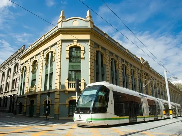
Medellín
Medellín earned its nickname honestly. At 1,500 meters in the Aburrá Valley, the temperature stays between 22 and 28 degrees Celsius all year. The locals call it the City of Eternal Spring, and that description is accurate enough to feel almost unfair to every other city in the world that has actual seasons.But Medellín's most interesting story is not its climate. For three decades the city carried a global reputation that made most outsiders afraid to visit. Then it decided to rebuild itself, not just materially, but in the imagination of the world. The result is cable cars that connect once-isolated hillside communities to the metro, outdoor escalators that transformed the steep Commune 13 into a public space, and a university culture that drives genuine civic pride. National Geographic named Medellín one of its Best of the World destinations for 2026.El Poblado is where most visitors stay: polished, walkable, and full of rooftop bars. Laureles and Envigado are where Medellín actually lives, in neighborhood parks, local markets, and the rhythms of a city that is completely at ease with itself. The traveler who ventures beyond El Poblado finds a city still in motion, and that motion is the most interesting thing about it.
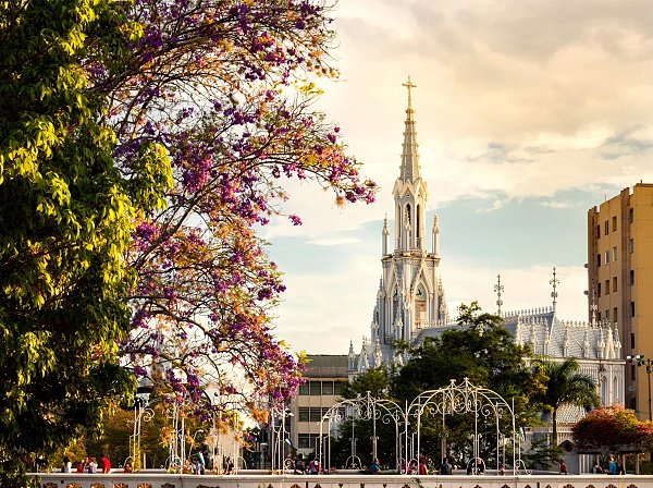
Cali
Cali does not perform salsa for tourists. It lives salsa the way a language lives, in the body, from childhood, without self-consciousness. The dance here is a product of the Afro-Colombian Pacific coast traditions that arrived in the Valle del Cauca over generations, and it developed its own distinct footwork and style, different from any other salsa form in the world. In the evenings, from the professional salsotecas of Juanchito to informal gatherings in neighborhood parks, the entire city moves to the same beat.Cali is Colombia's third largest city, sitting at the southern end of the Cauca Valley at approximately 1,000 meters above sea level. It is also one of the most important centers of Afro-Colombian culture in the country, with a food culture rooted in Pacific coastal traditions that are almost impossible to find outside the region. The traditional market of Galería Alameda, the largest and oldest market in the city, is where these food traditions remain most visible: fresh chontaduro palm fruit, lulo juices, and sancocho de gallina served by vendors who have been in the same spots for decades.Cali rewards travelers who approach it with good local orientation. It is a city that has received less investment in tourist infrastructure than Medellín or Bogotá, and that is precisely why what remains feels genuinely its own.
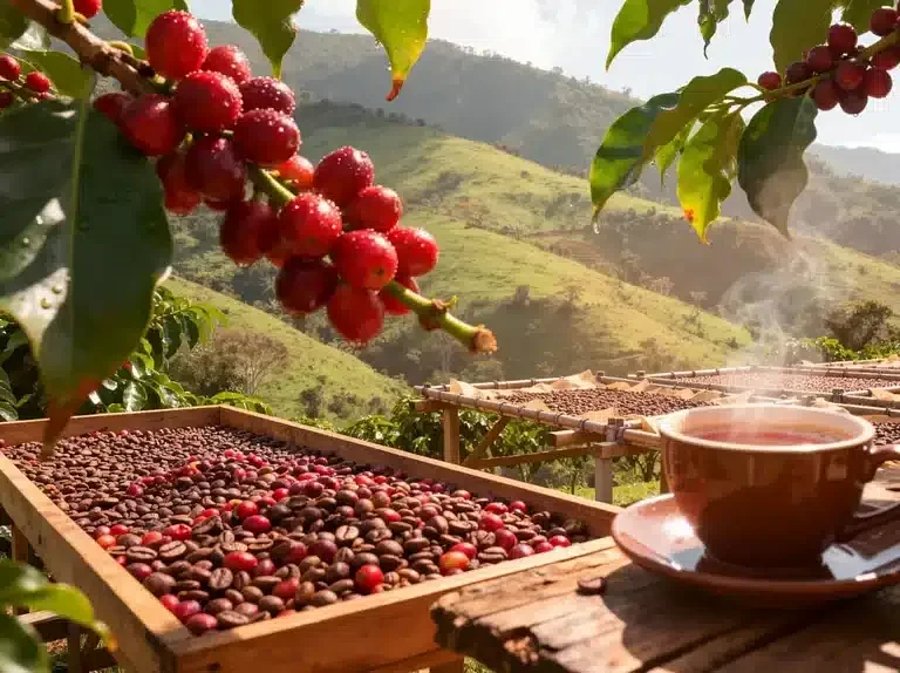
Eje Cafetero
The Eje Cafetero is three things at once. It is the most important coffee-producing region in Colombia, growing the Arabica beans that placed Colombian coffee among the most recognized in the world. It is a landscape of exceptional beauty: volcanic soil producing an impossible green, rivers cutting through steep ridges, and the Cocora Valley where wax palms, Colombia's national tree and the tallest palm species on Earth at up to 60 meters, stand against the cloud forest like sentinels. And it is a network of colonial towns, heritage pueblos with white facades and ornate wooden balconies, where the afternoon moves slowly and the coffee is always fresh.The UNESCO Cultural Landscape of Coffee-Growers of Colombia was designated a World Heritage Site in 2011. The designation recognized not just the landscape but the entire cultural system: the towns, the fincas, the wet processing techniques that separate Colombian Arabica from commodity coffee, and the family structures that built the region over generations. Salento is the most visited of the pueblos and for good reason, but Filandia, Jardín (in the neighboring department of Antioquia), and Circasia each have their own character and receive a fraction of the visitors.Visiting a working finca means following the coffee cherry from tree to cup, through the wet processing that happens in the hours after harvest. In the Eje Cafetero, slow travel is not a philosophy. It is simply the speed at which the place operates.
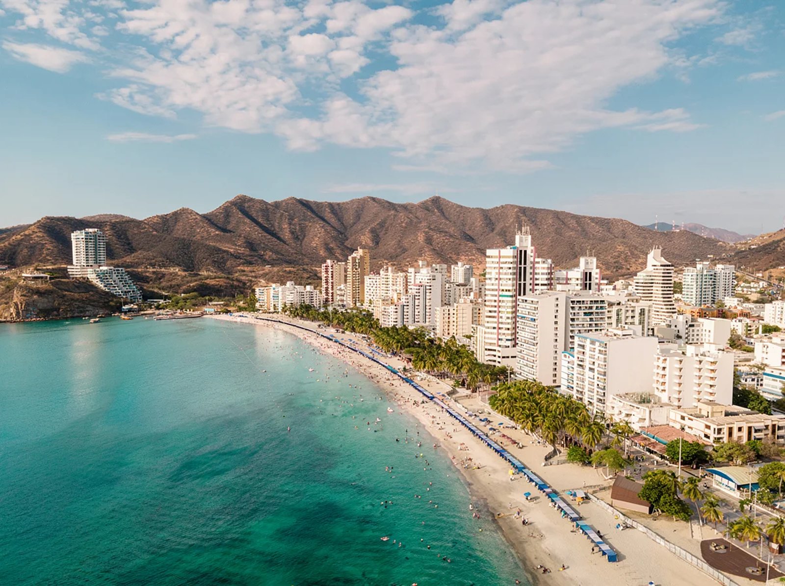
Santa Marta
Founded in 1525 by the Spanish explorer Rodrigo de Bastidas, Santa Marta is the oldest surviving city in South America. That distinction sits lightly on a city that feels genuinely alive rather than historically preserved. The historic center has cafes on colonial streets, the waterfront has a working harbor, and the Sierra Nevada de Santa Marta rises directly behind the city to 5,775 meters at its twin peaks, Pico Cristóbal Colón and Pico Simón Bolívar. This is the highest coastal mountain range on Earth, rising from sea level to permanent snow in less than 50 kilometers.Santa Marta contains multiples. Minca, an hour up into the Sierra Nevada by jeep, is a cloud forest village at 650 meters with coffee farms, waterfalls, and a temperature 10 degrees cooler than the coast. Taganga, a fishing village 15 minutes north, is the preferred base for divers exploring the Caribbean reefs. And Tayrona National Natural Park begins at the city's northeastern edge, where the road into the jungle ends and the trails begin.Simón Bolívar, the liberator of six South American nations, spent his final days in Santa Marta in 1830 and died at the Quinta de San Pedro Alejandrino, a colonial estate that still stands on the city's outskirts. The Kogi, Wiwa, Arhuaco, and Kankuamo communities, descendants of the ancient Tairona civilization, still live in the Sierra Nevada and consider the entire mountain range a sacred territory. Santa Marta is where Colombia's history and its oldest living cultures meet.
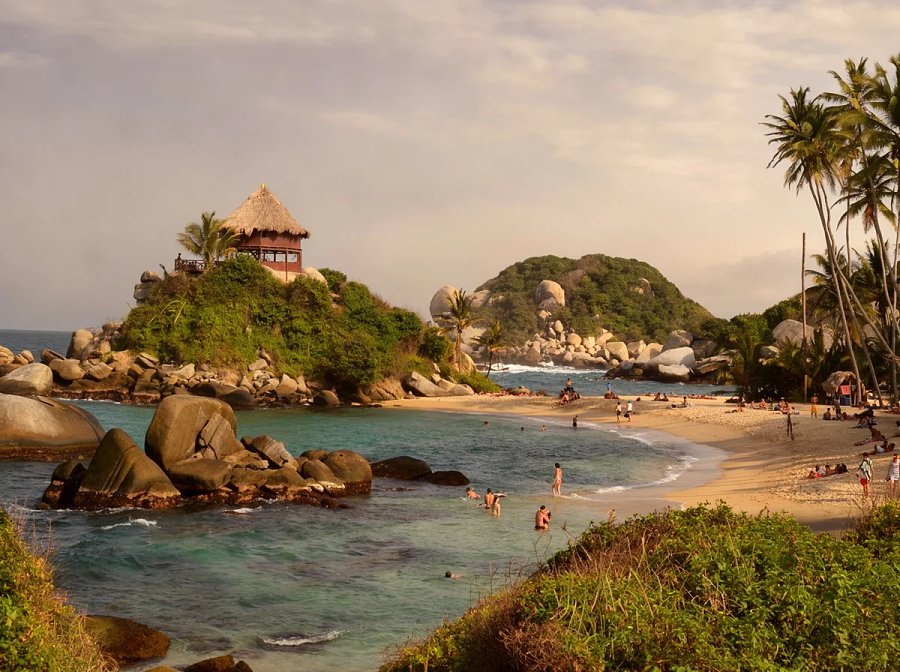
Tayrona
Tayrona is 150 square kilometers of protected land where the Sierra Nevada de Santa Marta descends directly into the Caribbean Sea. The forest here is dense enough to qualify as jungle, but it opens repeatedly onto white sand beaches where the water is shallow and clear, and where the sound of the ocean competes with birds you will not encounter anywhere else on Earth. More than 300 bird species have been recorded inside the park. The marine zone protects more than 100 coral species in Caribbean waters that remain some of the most intact in Colombia.The park was established in 1969. The Kogi, Wiwa, Arhuaco, and Kankuamo communities, descendants of the ancient Tairona civilization who built cities in these mountains long before the Spanish arrived, maintain ancestral rights over large sections of the territory. The three annual closures (February, June, and October-November) exist in part to allow these communities to conduct spiritual ceremonies on their ancestral lands, and in part to allow the ecosystem to recover from visitor pressure.Cabo San Juan del Guía is the most iconic point in the park: a headland where two beaches meet at the base of a forested hill, with hammocks strung under a traditional structure that has appeared in more Colombian travel photographs than almost any other image in the country. Playa Cristal (also called Playa Arrecifes del Paraíso), accessible by boat from the Calabazo entrance, has the clearest water in the park and has been ranked among the top 25 beaches in South America. The trails between them pass through forest that is never less than interesting.
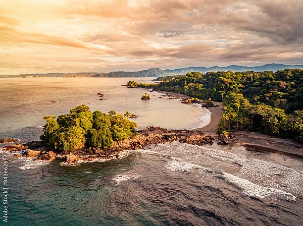
Choco
There is no gradual introduction to the Chocó. From Medellín or Bogotá you board a small propeller aircraft, land on a jungle airstrip, and step directly into one of the most biologically complex ecosystems on Earth. The Chocó bioregion spans Colombia's Pacific coast into northwest Ecuador and contains an estimated 9,000 plant species, more than 600 bird species, and levels of biodiversity that have made it a global priority for conservation science.The towns of Nuquí and Bahía Solano are the main entry points, positioned 50 kilometers apart on the Pacific coast of the Chocó department, surrounded by primary rainforest, with black sand beaches where the jungle reaches the treeline at the ocean's edge. There are no roads connecting these communities to the rest of Colombia. That isolation is the reason the ecosystem has survived. Between July and November, humpback whales migrate from Antarctic feeding grounds to these warm equatorial waters to breed and give birth. The bays around Nuquí and Bahía Solano are among the most reliable locations in the world for close-range whale encounters. Between October and January, three species of sea turtles, including the leatherback, the largest reptile on Earth, nest on these same beaches.The communities here are predominantly Afro-Colombian and Emberá indigenous, and the culture, the cooking, the music, and the relationship to the land and ocean are inseparable from the forest that surrounds everything. Visiting the Chocó is not adventure tourism in the conventional sense. It is an encounter with a part of the world that has not been made convenient for visitors, and that remains its greatest distinction.
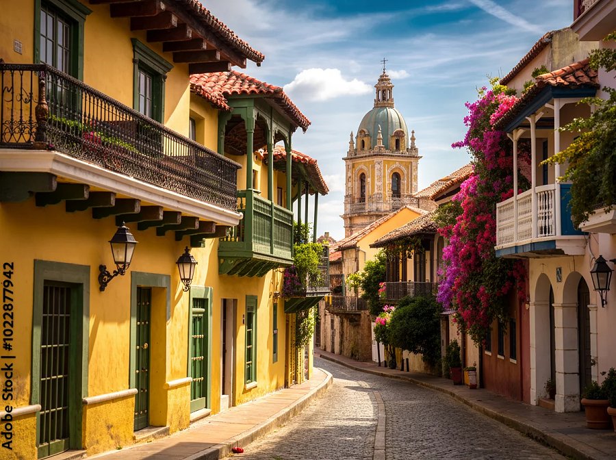
Cartagena
Cartagena is old in the best possible way. The walls of the historic center have been standing since the 16th century, enclosing a grid of narrow streets, baroque church facades, and balconies overflowing with bougainvillea. The reality beneath the postcard is more interesting: this was one of the most important ports in the Spanish colonial empire, the arrival point for enslaved people from West Africa and the exit point for gold leaving for Spain.That history is not decorative here. It lives in the architecture of Getsemaní, the former enslaved quarter now home to the most vibrant street art, local restaurants, and nightlife in the city. It lives in Palenque de San Basilio, a village 70 kilometers south that was the first free Black town in the Americas, established by escaped enslaved people in the 17th century, and a UNESCO World Heritage site since 2005. It lives in the cooking, which blends Caribbean coastal traditions with West African ingredients in ways no other Colombian city replicates.The Rosario Islands are a national park of 27 islands, 45 minutes by boat from the city. The water is Caribbean clear and the coral reefs are among the most accessible in Colombia. Cartagena is the Colombia most people imagine before they arrive. The surprise is how much more there is beneath the surface.
Want a destination that's not here?
These are the places where we already operate with local experts. If you have somewhere else in mind, or want to combine several, we'll build it with you.